|
Port
of origin: Vancouver
Dates: May 6-16, 2000
Ports of call: Skagway, Haines, Juneau, Ketchikan
Ship: Norwegian Wind
Sunday, May 7, 2000
Alaska. The "last frontier." The land of the midnight sun. Who
would have ever guessed we would be on a cruise to Alaska? Certainly
not me! We're on the Norwegian Wind, on a 7-night cruise from
Vancouver, British Columbia to Skagway, Haines, Juneau, and Ketchikan
Alaska.
We flew to Seattle (Washington), and arrived around noon. We were
surprised to see that it was sunny - weather reports said it would be
in the low 60s, but you always picture Seattle being cool and rainy.
We had a perfect day – high 60s and lots of sun. We dropped our bags
at our hotel, and left to do some sightseeing.
The Space Needle was only a couple blocks down the road, so we
walked. It was built in 1962 as part of a World's Fair, and is
currently undergoing some major reconstruction and renovation. It
will have a "grand reopening" next month at the same time the Rock `n
Roll Museum is being opened next door – the architecture of
that "building" is quite interesting – evidently it's supposed to
represent the inner-ear. Around the Needle is Seattle Center (once
the World Fairgrounds), which covers 74 acres, and where you can find
the Ballet, Opera, theaters, sports, Children's Museum, Pacific
Science Center, Space Needle, Fun Forests Amusement Park,
International Found, and the start of the Seattle Center Monorail to
the heart of downtown Seattle.
We purchased our tickets for the Space Needle, and took the 43-second
elevator ride to the Observation Deck, 520' above ground. At the
top, we had a 360° view of Downtown Seattle, Puget Sound, Lake Union,
Mt. Rainier and beyond. There is a restaurant at the 500' level, but
reservations are required far in advance, even for lunch.
The most amazing part of the view was Mt. Rainier. When we were on
the Needle, we looked out, and saw lots of clouds… and then realized
it was the top of a mountain in the middle of the clouds! It truly
looked as if it was out there in the middle of the sky! The top is
covered with snow, and was surrounded by white clouds, so it was
almost like a ghostly white specter, hovering in the distance.
We took the monorail from the station near the base of the Needle,
and took the 5-minute ride into the town. Then we walked about 8
blocks down to the water, and ate at Ivar's restaurant, where we
could watch the boats go by. The food was excellent! They are known
for their chowder, and we now know why – even the kids loved it.
Monday, May 8, 2000
We got up early and took the train from Seattle to Vancouver, where
we would get on our cruise ship. The weather this morning was a
little more like we expected – it was 47 degrees, and started
drizzling when we got into the cab. The train ride was great – they
even played a movie for us to watch!
We had an advantage on the cruise ship – we had taken a cruise on the
sister ship, the Dream, a year ago, so we already knew our way around
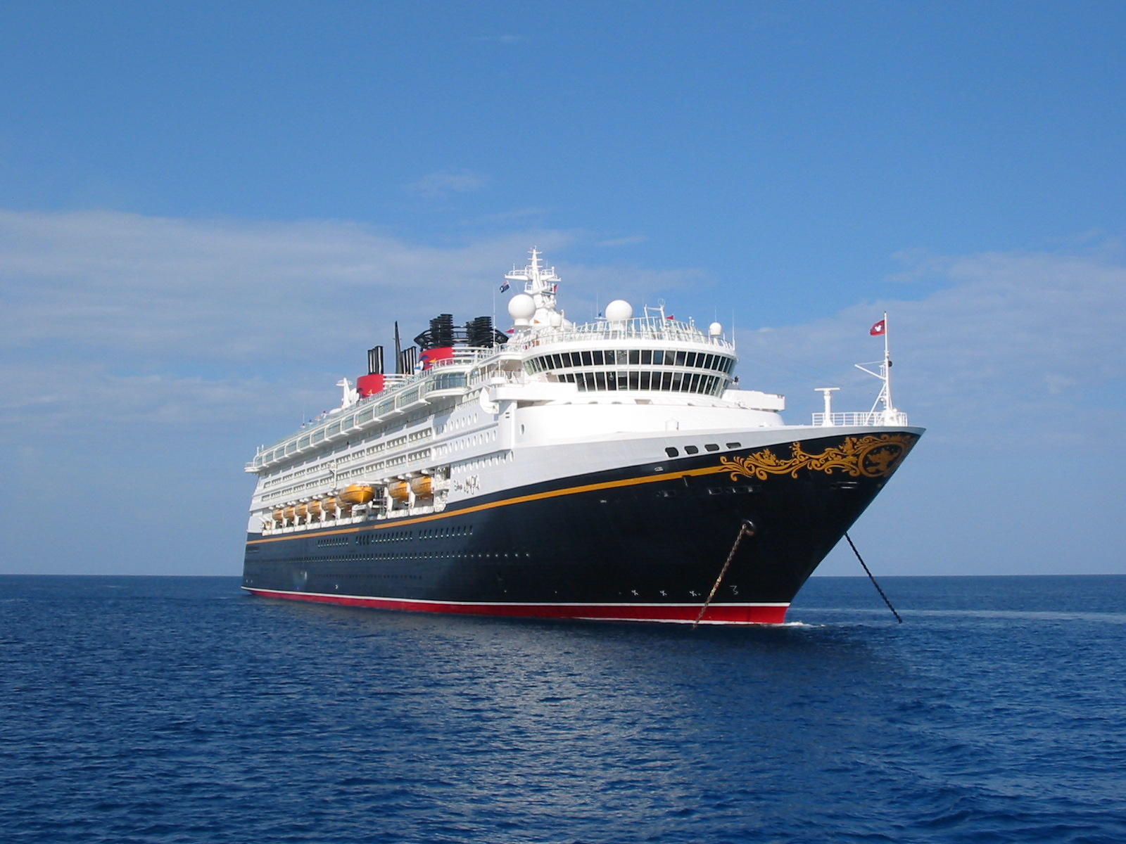
the ship! The Norwegian Wind was originally built as the Windward in
1993 (maiden voyage was May 14). Former First Lady, Barbara Bush,
christened her in Los Angeles. It was built in France at a cost of
$240 million. In 1998, it was sent to Germany, and 130' feet were
added on, in the middle (they cut it in half). They then renamed her
the Norwegian Wind. Her new total length is 754', width of 94', and
height of 164'. Average speed is 23 mph (20 knots). Passenger
capacity is 1,750, and crew is 614.
The weather is pretty nice again – no rain clouds in sight, light
jackets for the wind, but not heavy ones. The sun is shining, and
it's probably in the low 60s.
Now the decision I had been dreading – how to choose our excursions
from the 10-page book of options?! There are two kinds –
the "excursions" and the "adventures". The latter consists
of biking,
hiking, rafting, and kayaking trips, most of which the kids were too
young for (or we're too out of shape for). They even offer a scuba
diving trip in Ketchikan – can you imagine? Brrr… Excluding those
20 trips, there were still 11 in Skagway, 9 in Haines, 15 in Juneau,
and 10 in Ketchikan. They range in price from $28 per person for a
salmon bake, to $339 per person for a helicopter that lands on a
glacier where you get out and walk to the dog sleds and ride/drive
them for 20 minutes before flying back over waterfalls and glaciers.
That last one was my personal favorite until I investigated further.
Originally that was to be done in Juneau, but they evidently haven't
flown the sled team up there yet, so it's in Skagway, and the dog
sledding is a lot shorter and not a real ride, like it is in Juneau.
Good… saved a few dollars there!
We finally chose the Glacier Point Wilderness Safari. The description
in the book is:
This tour offers a unique opportunity for a close look at
the "friendly edge" of Alaska's wilderness by air and on foot. Begin
with a 20-minute scenic flight over Alaska's deepest fjord to a
remote beach landing strip on the tip of Glacier Point, 20 miles
south of Skagway. You'll be met by experienced wilderness guides who
will share their extensive knowledge and love of the glaciological,
cultural, and natural history of this area. Next, board a four-wheel
drive vehicle for a short drive to a trailhead, then take a Ľ mile
walk with your guide, crossing the terminal moraine of a glacier.
When you come to the edge of a lake, the glacier will be looming
right in front of you! Then board a 31' canoe for a voyage of
discovery among the icebergs. This is truly a journey back in time,
with a first-hand glimpse of the remnants of the last Ice Age. Return
along the same route to the beach, where you'll enjoy a tasty snack
of smoked salmon, cookies and warm beverages. You'll see more
spectacular scenery before your return flight to Skagway.
It says it returns you to Skagway, but actually the tour is from 2:45
pm to 7:15 pm, and the ship leaves Skagway at 6 pm. It goes 15
minutes across the water to Haines for the evening (6:30 to 11pm), so
we'll actually go to Haines and meet the ship there. This eliminates
the possibility of any tours in Haines, though, as they all leave as
soon as the ship arrives at 6:30.
This tour sounds great to us – a flight, icebergs, fjords, a glacier
walk, and a canoe ride. It incorporates what we liked about a lot of
the different tours, but puts it all in one, which essentially is
more economical. This tour is $204 per person. A flight alone is
$135 per person. A canoe ride is $84 per person. The glacier walks
can only usually be done with the helicopters, which are $185+ per
person. So we did this one, to combine a few adventures into one.
For Juneau, we decided on the Juneau Wildlife Cruise. It's 4 hours
long, and $112 per adult and $75 per child, but they guarantee you'll
see at least three species of wildlife besides birds or they give you
$40 back per person right there on the boat. Their brochure
says, "you'll have the opportunity to see humpback whales, Dall's
porpoises, harbor seals, Steller sea lions, bald eagles and more –
our skilled crew is so good at locating wildlife, we guarantee it!
Last week, in preparation for our trip, we watched "White Fang," so
the kids have some knowledge of the Gold Rush and panning for gold,
and knew that would be important to them. There are two "gold
tours" – one is at the same time as the wildlife cruise, the other is
in the morning in Skagway (8:30 to 11:45). Since our wilderness
safari doesn't leave until 2:45, there's plenty of time to do it then.
It's actually called "Klondike Summit & Trail Camp," and is
described
as:
This exciting tour takes you from the foot of a waterfall to the
heights of the White Pass Summit, 3290' above sea level. The White
Pass Trail of '98 begins in Skagway's historic downtown, with its
wooden sidewalks and false-fronted buildings. Head out of town on a
road that parallels the route of the famous White Pass & Yukon Route
Railroad, an engineering marvel. On the way to the summit, your
driver will regale you with stories of the stampeders as you follow
in their footsteps along Brackett Wagon Road, past Dead Horse Gulch
and into a land known as Tormented Valley. The beauty of the
surrounding mountain peaks, waterfalls and glaciers here is
spectacular. Then enjoy a visit to Liarsville, a Gold Rush trail camp
recreated on the very spot where it stood a century ago, nestled in a
lush forest at the foot of a small waterfall. A snack and cup of hot
cider will warm you as you wander among the supplies left behind by
the stampeders, and meet a Mackenzie River husky or giant malamute,
the huge and friendly sled dogs of the North. Music will beckon you
to the Liarsville Hippodrome, where the madam tells tales of the
notorious Red Onion Saloon and a sourdough recites some of the
whimsical poems of Robert Service. If you came seeking gold, you're
guaranteed to find it in Liarsville, and better yet, you can keep all
you find!
That excursion is $44 per adult, $28 per child. So, all together,
our excursions will cost us $1344. That's more than the cruise is
costing us! And we didn't even sign up for excursions in Haines or
Ketchikan – we'll explore those on our own.
I attended the presentation on excursions, even though I had already
made up my mind. In each city, the cruise director had his "5 star
picks" – only 1 or 2 per port. In Skagway, his recommendation was the
wildlife safari, the one we had chosen. In Haines, he didn't really
have a favorite. In Juneau, he liked either the Glacier Expedition
via helicopter, or the Juneau Wildlife Cruise (also our choice). In
Ketchikan, he recommended the Misty Fjords Cruise and Flight, but
that would have been another $730 for us… we didn't select an
excursion in Ketchikan.
Tuesday, May 9, 2000
Alyx and I pulled out the book "Alaska," by Donna Walsh Shepherd,
from the America the Beautiful series. It was just published in 1999,
so it's very current and has lots of great photographs. We read that
the first inhabitants of Alaska came 7000 years ago from Asia, across
a land bridge that appeared for only a short time in history. In the
18th century, Czar Peter the Great sent Vitus Bering to map the far
eastern shores of Russia, and he sailed to Alaska through what is now
known as the Bering Straits.
Last summer, the Norwegian Sky became the first cruise ship to have
Internet access (they opened an Internet Café), and it was so
instantly popular that not only did NCL put one on every ship in
their fleet, but other cruise lines have now done the same thing. The
room that was the library is now the Internet Café. Their computers
are hooked to the Internet via satellite, and the cost is 75 cents a
minute. You can also send a video email for $5, using their video
cameras on the top of their monitors.
It is DEFINITELY colder today – we wouldn't venture out without our
heavy winter coats, as it is quite windy. Actually, a very popular
place on the ship appears to be the decks on the back of the ship –
plenty of sun and views without all the wind.
Later in the afternoon, we were walking on the deck and stopped to
look over the railing – and saw whales! There were a few of them in
the water, spouting water, showing their tail fins… They were
probably humpback whales, which are common in this area. We used our
binoculars, but it was still hard to get a really good look at them.
Trevor was cold (he only had his sweatshirt jacket on), so we went
down to the room to watch the whales from our windows and porch. I
did manage to catch a picture of the tail fins in the water, but it's
not great. We'll see more, I'm sure.
We can also see a lot of white areas by the shoreline, and using the
binoculars could see that they are large pieces of floating ice.
They're rather far to take a picture of, though.
Today we are sailing the Inside Passage, which is a narrow strip of
mainland, made up of thousands of Islands and Fjords. It is bounded
by the Pacific Ocean on the west and by Canada on the east. It lies
to the southeast of the rest of Alaska, and is therefore known as
the "Alaskan Panhandle."
There are many mountain ranges surrounding the Inside Passage, and
they were formed by glaciers that carved deep U shaped fjords, which
were later flooded by the sea thousands of years ago.
In southeast Alaska, there are 50 varieties of berries! The most
plentiful of these are blueberries and salmon berries. No, I don't
know what salmon berries are either, but I'll let you know if I find
out.
We are going quite slow, just drifting through the Inside Passage.
The water is very calm, so there's only a very gentle, rolling
motion.
Wednesday, May 10, 2000
According to this morning's "Cruise News," sunrise was at 4:51 a.m.,
and sunset will be at 9:04 p.m. They also listed some facts about
Alaska:
· Alaska is over 2.5 times the size of Texas
· The city of Anchorage alone covers about 2,000 square miles,
roughly four times the size of Los Angeles. At 3,000 square miles,
Juneau covers more area than any city in the U.S. It is also the
only state capital that cannot be driven to (you must fly or come in
by boat).
· There are more than 5,000 glaciers in Alaska. One f them is
larger than the state of Rhode Island.
· The state's tidal shoreline measures 47,300 miles.
· The total area of Alaska is 586,412 square miles, with a
population of 550,000.
· Alaska has 1.06 square miles per person. In comparison, New
York has .003 square miles per person.
The kids and I read an illustrated version of Jack London's "Call of
the Wild" to the kids. I was surprised – I thought the book told a
little more about Alaska, but it was really just a dog-in-Alaska type
of story, not as good even as "White Fang." Rather violent in its
descriptions of dogs fighting, even though this was just an
illustrated version for kids.
All day, we have been cruising between land masses – at times the
waterways seem to be over a mile wide, at times it seems there's land
very close on both sides. The water was quite choppy this morning,
and we were going at a faster speed. During lunch, we looked out
the restaurant windows, and there are now more snowcapped mountains
on both sides of the ship. I thought we were cruising among glaciers
all day, but evidently we don't reach Sawyer Glacier until 5 p.m.
Vic and I attended a "lecture" on glaciers and fjords. First of all,
the mountains in Alaska, as well as those all down the western coast
of North and South America, are caused by the fact that it's the
meeting place of a couple tectonic plates. These are deep under the
crust of the earth, and one is more dense and heavier than the other.
The one that's heavier sinks down under the second one in the place
they meet, and the lighter one rises as the other moves under it,
causing the mountains to rise.
Anyway, the glaciers are formed when layer upon layer of snow builds
up, and there is less ice melted during the summer than accumulates
in the winter. This has not been the case in more recently geologic
history, which is why the glaciers are melting and receding. The
glaciers are constantly moving and changing as they grow or melt,
taking lands with them in masses that mix with melting snow and ice,
called moulins. They are also giving some of the land back,
leaving "scratches" in the rocks (called striations) as it recedes. A
fjord is where the glacier has receded, leaving a crevasse in the
rocks or mountains around it, and its filled with water. Cirques are
circular areas where mountain glaciers are melting downhill, creating
a u-shaped area in the top of the mountain.
The glaciers often appear to be turquoise or blue in color, caused by
the bubbles of air that have been trapped in the ice for hundreds of
years. The sunlight reflects off these bubbles in such a way that the
blue color is refracted, making the glacier look blue. They have
actually tested the air that comes out of these bubbles, and found
that the air quality today is much different than it was even a
hundred years ago – much more pollution and greenhouse gasses exist
in our air today. This is contributing to the diminishing of the
glaciers. If they melt enough, our big cities are in trouble – most
of these are at sea level, and if the ocean water level rises… people
in these cities might want to invest in canoes.
Last night we had to set our clocks back another hour, so we are now
4 hours different than the east coast.
We watched for the glacier for quite some time – looking out our
starboard side windows and porch, watching the front of the ship on
TV from a video camera on the bridge. There were lots of large chunks
of ice floating around in the water, some small and some on the
larger size – they're called icebergs, but none were bigger than a
few feet long out of the water. While we were waiting, I read more
to the kids about Alaska's history, this time going from the early
18th century, through the Gold Rush, the purchase of Alaska from
Russia for 2 cents an acre, the strategic positioning of Alaska
during WWI and WWII, the poor treatment the Aleuts received during
WWII, and finally becoming the 49th state. We read about the
pipeline built to bring the oil down to Valdez, the various climates,
and the multitudes of wildlife species.
We went out on deck, and looked up and were greeted by the sight of
big mountains on either side of the ship, only 50' at most from us.
The ship seemed so large before, now it seems so small. Finally, we
turned a corner and there was a glacier on the left, and Sawyer
Glacier was ahead to the right. We had learned in the lecture today
that it would be turquoise blue, but I have to admit – it wasn't as
blue as I thought it would be. The glacier ice came down to the
water, and seemed to be a large frozen mass of water waiting to
cascade down from the mountains. But it was quite white, with only
glimpses of turquoise blue at the very center. Some of the floating
pieces of iceberg were obviously blue, so I took a few photos.
Finally, they announced that we couldn't get any closer, due to the
amount of icebergs floating nearby, so we turned around.
I guess I've seen too many of the Holland America Line's commercials,
showing the ship coming up near an iceberg with falling bluish ice
coming down the face. I expected large, huge, massive, intimidating.
I saw a pile of ice.
Thursday, May 11, 2000
This morning's "Cruise News" says the sunrise was at 4:37 a.m., and
the sunset at 9:17 p.m. It also gives background information on our
two ports of call for today.
Boomtown Skagway: The Gold Rush of 1898 drove wave after wave of
fortune-seekers north through the town of Skagway. The town grew
until its inhabitants numbered over 10,000. Those years gave Skagway
a reputation as a lawless frontier town run by reckless gamblers.
During the first year of the Rush, an estimated 20-30,000 98'ers
crossed two perilous trails – the White Pass and the Chilkoot, from
Skagway to Canada. Finally, the White Pass and Yukon Railroad was
built over White Pass into the Canadian Klondike. Skagway remains a
Gold Rush town thanks to the spirit and enthusiasm of its people. The
White Pass and Yukon reopened for passenger traffic in 1988, and
today the wooden sidewalks, old-fashioned saloons and horse drawn
carriages serve as reminders of the "Days of `98".
Trading Trails: The original Haines, adjoining the fort, had begun as
a trading post and Presbyterian mission in 1879. Until then the
Chilkat Indians had controlled that strategic spot where the
waterborne commerce of Southeast Alaska connected with ancient
trading trails. The modern Highway follows much of the route of those
Indian pathways. Decommissioned in 1944, the fort was acquired by
private owners, renamed Port Chilkoot, and later merged with the
original settlement to form the city of Haines.
The book I had purchased, "Alaska Ports of Call, what to see and do
when you go ashore," published by Fodor's, described Skagway as: The
early Gold Rush days of Alaska, when dreamers and hooligans descended
on the Yukon via the murderous White Pass, are preserved by Skagway.
Now a part of the Klondike Gold Rush National Historical Park,
downtown Skagway was once the picturesque but sometimes lawless
gateway for the frenzied stampede to the interior goldfields. Local
park rangers and residents now interpret and re-create that
remarkable era for visitors. Old false-front stores, saloons,
brothels, and wood sidewalks have been completely restored. You'll be
regaled with tall tales of con artists, golden-hearted "ladies,"
stampeders, and newsmen. Such colorful characters as outlaw
Jefferson "Soapy" Smith and his gang earned the town a reputation so
bad that, by the spring of 1898, the superintendent of the Northwest
Royal Mounted Police had nicknamed Skagway "little better than a hell
on earth." But Soapy was killed in a duel with surveyor Frank Reid,
and soon a civilizing influence, in the form of churches and family
life, prevailed. When the gold played out just a few years later, the
town of 20,000 dwindled to its current population of just over 700
(twice that in the summer months). Virtually all the shops and Gold
Rush sights are along Broadway, the main strip that leads from the
visitor center through the middle of town, so you really don't need a
taxi. Horse-drawn surreys, antique limousines (old Yellowstone park
buses), and modern vans pick up passengers at the pier and along
Broadway for tours. The tracks of the White Pass and Yukon Railway
run right along the pier; train departures are coordinated with
cruise ship arrivals.
We had set the alarm this morning for 6:45, as our tour left from the
pier at 8:30. We woke up at that time and looked out – the sun was
so bright already! Vic and I took showers, and then we all got
dressed. On each of the kids, we left their "long john" pajamas on,
and then put their clothes over it – a heavy shirt and pants for
each. We also put extra warm socks on them, and then their boots that
Vic bought before we left Florida. Then they each had a sweatshirt,
then their jackets. We put the hats and gloves in the backpack. Vic
and I wore similar layers of clothes. We ate breakfast in the
Terraces restaurant (the Sun Terrace wasn't open this morning), and
then went down to the pier to meet our tour bus.
We left at 8:30, in a bus that holds 50 passengers. The driver, Kate,
is from Oregon, and has lived in Skagway for the summers for 3
years. She drove us around town a little, and gave us some
highlights as we passed. A lot of the older buildings were actually
moved – once the gold rush was done, the buildings closest to the
pier were abandoned, run down, and an eyesore. There were continual
cruises into Skagway from about 1910, but it wasn't until later that
that they decided to clean up downtown, and moved the more historic
buildings (like the Red Onion Saloon) closer to the pier. We also
saw "pics" which were little tiny houses not much bigger than a
playhouse, where miners could obtain "negotiable affections."
While we were driving out of town, Kate told us about the Skagway
River. There's too much silt from the glacier melts to maintain any
fish other than the hooligan fish, which is very small, only 3 or 4"
in size, in the smelt family. The unusual thing about this fish is
that it contains so much oil that throughout the history of this
area, this fish has been caught, dried, and then burned as candles,
giving it its nickname of "candle fish." They were a valuable
trading commodity – caught in the summer, dried, then sold in the
winter when there are only as little as 6 hours a day of sunlight.
Our first real stop was Liarsville, an old tent city. It's on the
site of actual old tent city. The miners had to bring one year's
supplies with them into Canada (or they wouldn't be allowed in). The
weight totaled nearly 2500 pounds, so the miners would take 40-60
pounds of their supplies, leave it in a tent city, then go back and
get another load, and back and forth and back and forth. When all
their supplies were together again, they would move on to the next
tent city with another load, after load, etc., etc.
All the buildings in the tent city were temporary, of course – the
laundry, bar, food, and brothel. The current area is set up the same
way, with a few exceptions. There is a gift shop (from which we
purchased some moose and salmon bottle openers, little tiny bottles
of gold flakes, and a license plate game for us to play on our trip
north in a couple weeks. There is also a "hippodrome" area where
they put on a little "show" about the area's history. The kids also
saw a malamute – a sled dog! He was so big! We were given time to
wander through the tents, given hot cider and ginger snaps, and then
shown into the show area.
The show started with the malamute, named Kobuk. They explained that
he was bred to eat only about 3 cups of food a day, so that when his
ancestors were one of many dogs on a sledding team, they didn't have
to carry a lot of dog food with them. He weighs 175 pounds, and is
actually very sweet. He could consistently pull weights of 500
pounds, and for short spurts could pull as much as 2500 pounds. The
speedier dogs, as in the Iditarod Races, have been bred with faster
dogs, like greyhounds, for speed rather than endurance. There are
three male actors, one female actress, and a guy who plays a little
accordion for musical accompaniment. They do a little presentation
about what a miner would have gone through in his quest for gold, and
then the "madam" comes up and relates a little history of women in
the area. Then the players act out a Robert Service poem (a poet who
wrote about the rush and Alaska) about a man who paid for a coffin,
but was frozen solid in such a position that he wouldn't fit.
They then showed us how to pan for gold. Using a pie tin with gravel,
dirt, and a little bit of gold flakes (planted there by them, of
course), we went to water troughs, put some water in the pan, and
sloshed it around. Using the water and gravity, we kept shaking the
pan around, getting rid of the gravel and dirt on top with the water,
leaving only gold flakes on the bottom. Gold is heavier than the dirt
or stones, so it will sink to the bottom. Once the flakes were all
that was left (or visible enough, anyway), you took your little tiny
ziploc bag and filled it with water. Then you dried off your fingers,
and touched the gold flake. It stuck to your finger, and you put it
in the water in the bag, and it immediately sunk to the bottom
because of its weight. Then you drained all the water out of the bag,
and you had a little bag with your flakes of gold in it! They gave
Alyx and Trevor a double portion of the dirt, and Vic and I combined
our finds with those of the kids, and still they each ended up with
only 6 or 7 flakes each. Of course, one of the ironic things about
this is that there was no gold ever found in Skagway!
I'm not sure which was the highlight of the stop for the kids –
panning for and finding gold… or seeing and touching the giant
malamute dog! After the show, we took pictures with him too. When we
were leaving, I asked how many groups a day go through Liarsville,
and they said they had 4 today, but in the summer it could be 6 or
7. I think some of the tours even include a salmon bake at
Liarsville as well.
Next our tour bus went up to the White Pass Summit of 3,292 feet
above sea level. Not very high in comparison to other elevations,
but because of its proximity to the poles, it is practically a frozen
wasteland where nothing grows. Evidently they don't get a lot of snow
here each year – the wind is the tough part. On the way to the
Summit, we passed a glacier that is actually the first (or actually
last) in the Juneau Icefield. You could walk from here to Juneau on
the ice over the field. Outside of the poles, the Juneau Icefield is
the largest in the world.
At one place, we went over a bridge, and Kate said it was secure on
one side, but not on the other. The reason is that it is right on a
fault that sees about 80 tremors a day. Most are too small to even
be felt, but the bridge needed that flexibility, so it was specially
designed to be able to withstand the tremors. It is actually toward
the northern end of the same fault that's near California – the San
Andreas Fault.
Then our bus went to Tormented Valley. If you want to see what this
area looks like in the summer, you can rent the video "Never Cry
Wolf," which was filmed here one summer about 15 years ago. It was
filled with snow, and the kids were thrilled. Luckily (thanks to
Vic) we were all wearing boots, so we went out and walked down the
snow into the valley a short distance. Some of the other people were
sinking in the snow – some up to their thighs! We took a few
pictures, the kids made a few snowballs, and we went back to the bus.
Kate then asked the nationality of anyone who wasn't American. We had
crossed into Canada, and would now be going back into Alaska, so she
needed to know for the border crossing. At the crossing, she told the
total number of people on board the bus, the numbers of each
nationality (2 from Nassau Bahamas, 2 from Ottawa Canada, 2 from
Czech Republic, 2 from Germany, and 4 from Argentina). The guard
wrote it down and waved us on. Kate explained it was probably one of
the easiest border crossings in the world… it's only manned for 18
hours a day, so from the hours of midnight to 6 a.m., when no one is
in the building, you pull up to a gate, and do a video recording.
You press the button to start it, and give it the information they
ask for (names, citizenship, license plate number of vehicle) for
each person. Then at the very end, it even asks you if you have
anything to declare, which again you do into the video recording.
Kate then recited her own favorite Robert Service poem,
called "Klondike Fever." It was quite long, and was about a man who
struck it rich in Alaska, then went home with his riches. He was
soon missing Alaska – he had come for the gold, but had found a new
land that truly got under his skin.
Kate talked about the two ways that prospectors could get up to the
Klondike. The gold was actually to be found in Whitehorse, which is
in Canada and is 500 miles away from the sea. They would come into
Skagway, take either the White Pass or Chilkoot Trail up to Lake
Bennett. There they would make a boat that would take them 400 miles
upriver to Whitehorse. Anyway, the Chilkoot Trail begins with a hike
up a mountain. An enterprising father and son carved steps into the
side, and maintained the steps, charging prospectors to climb up.
These were what we saw in the movie "White Fang," called the Golden
Staircase.
Chilkoot Trail is now a National Park as well. Years ago, locals
tried to convince the government to make it a national park, but when
they came up to look, they saw too much "trash." The prospectors, who
couldn't carry all their supplies up, would dump them right off the
trail, so it was littered with pans, clothes, tents, etc. They felt
then it would take too much to clean up the area to make it a park.
In 1977, the locals tried again. This time the representatives of the
park service said "Wow! Look at all this great trash – what a
historical record of the Gold Rush!" Now it's all like a 30-mile
long museum. The National Park Service created the Klondike Gold Rush
National Historical Park, and bought and restored many important
buildings in Skagway as well.
We also entered a rainforest – Tongass Rainforest covers southeastern
Alaska, and we were at the very tip of it. Too far south to actually
get any rain, but technically in the rainforest.
We actually dressed quite appropriately – in fact, if anything we
were a little overdressed. But better warm than cold! For our
afternoon excursion, they specifically said to "dress warmly," and we
will be in a canoe, so we're leaving our clothing on. We're not
going to bring the raingear, though.
Back to town – Kate explained that the town was pretty quiet in the
winter – only 7 businesses stay open (video rentals, 2 restaurants
that alternate breakfast and dinner seatings every week, grocery
store, bar, school and post office). We asked when the season
started, and Kate said we were only the second ship of the season –
the first came on Sunday, and it was a little 98-passenger cruise
ship. The shops stopped their cleaning and opening preparations long
enough to service the people in town, then closed again until today.
Anyone who wanted could get off the bus in town, rather than 6 blocks
away at the pier where our ship was. It was 11:30, so we went back to
the ship for lunch. From our table, we watched the helicopters and
airplanes take off from the very small airport. Kate had told us
that there was no control tower – the pilots just communicate amongst
themselves as to who is next. In the summer, it is a very busy
place – flights take off every 5 minutes!
Our afternoon tour left at 2:45 from the end of the pier. After
signing the waiver, we hopped on an old school bus (with padded seats
better than I remembered from school days). We rode the less-than-5-
minute ride to the airport, where six small 5-passenger planes were
waiting. They put a woman with us who was traveling alone, and we
took off. We were behind 3 of the other airplanes when we left. We
flew south out of Skagway, past Haines on the left, then around in
front of Davidson Glacier, and then down on the runway on the beach
near it. We were met there by a bunch of "adventure guides," who put
us in a four-wheel drive vehicle all right – another old school bus
on which they had put 4-wheel drive. And we did need it – once the
bus almost didn't make it up a hill. After a 10-minute ride, we
stopped at a shack, where, after quick rest stops in the fancy
outhouses, we put on their rubber boots. We also put a windbreaker on
Trevor over his coat.
From there, we hiked Ľ mile to the water. It was up and down hill –
nothing too strenuous, but not a walk down the street, either. The
guide pointed out various types of plants on the walk, and the kids
were right in the front of the group listening (there were 29 people
in our group total). During the walk, I spoke with Diane, the woman
who had ridden with us on the airplane. I asked if she was on the
cruise alone, and she said no, she was with her parents, but she had
left her family at home. Her parents hadn't been interested in this
particular excursion because of the flight. I asked about her
family, and she said her husband couldn't get off work, and her 8-
year-old son had school. I said that's the reason we homeschool, so
we can bring our kids along for our learning adventures. She said he
goes to private school, and they wouldn't let him miss school for
travel. Funny, I always thought the parents were the ones who knew
what was best for their child.
At the end of the trail, we put on life jackets, and were assigned to
one of 3 10-person canoes. Alyx asked to sit in the front of ours,
so she did, and Vic, Trevor and I sat in the second row. Trevor
wanted to row, but since it had turned a bit windy, the guide thought
it best if the adults rowed. At first it was quite easy, but then we
hit an area where we really had to work hard. We kept getting stuck
on shallow areas, and then the wind would blow us backwards. The
first boat had no problem, but because we were stuck, we were
blocking the third canoe, which was behind us. We even bumped into
them a couple times. Our guide got out and pushed a couple times –
he had on the rubber boots too, but the water was deeper than his
boots. The canoe does have a motor on the back, but the water was
too shallow to use it. We kept trying, and finally made it.
Once past the shallow area, we turned the motor on, and cruised
around the small lake made by the melting glacier. There were even a
few "icebergs" floating around, and we went and touched one. The
guide broke off a piece of the top, and we passed it around. There
were a few larger icebergs, but the guide said they don't go close to
it because what we see on the top (which was a good size) was only
10% of the mass, usually – the rest is underwater. They also tend to
roll over unexpectedly.
We used the motor to go as close to the glacier as the guide dared. A
few days ago, a piece of the glacier suddenly broke off. At the area
where we boarded the boats, a few hundred feet away, it caused a wake
2' high. If we were close to the glacier when something broke off….
The weather had been so nice at the beginning of our adventure – we
had jackets, but were carrying them, not wearing them. Once we got on
the beach and had to put life jackets on, we put our jackets on
underneath. Even at the beginning of the canoe trip, it was still
comfortable. But as soon as we got near that glacier, the wind really
picked up, and the air blowing off the glacier was cold! I put on my
gloves, and we all put our hats on. At one point, Trevor was even so
chilly that he took Vic's hat and held it over his face. I think I
got a sun or windburn on my face – it's a little red in the cheeks
and nose.
We had a great view – the glacier on one side, in the middle of a
small glacial lake, and a range of mountains on the other. The water
was a nice color – light bluish from the color of the glacier. We
put our hands in the water to feel – it was freezing! The guide said
the water temperature was probably about 33°. It finally felt like
we were in Alaska!
After going around in the water for a while, the guide told us we
were heading back, and gave the order "All forward!" We rowed back
to the beach, and it was a lot easier downstream! We had been going
against the wind and against the water flowing from the glacier
before, now we were basically rowing once in a while to help steer.
We got out of the boat, and took off our life jackets. Our guide got
out, and took off his boot. When he turned the first upside down, a
stream of water came out – the freezing water he had stepped into. I
asked if he could feel his toes, and he said not really… but he
wasn't complaining.
On the way back to the shed, the guide explained that he and all the
others live on Davidson Glacier Point during the summer. They have
cabins, their supplies are brought in my plane or boat, and there is
one common cabin with electricity provided by a generator that is
used when necessary. The guide was previously working in Seattle for
an Internet company, but had felt the need to be in the outdoors, so
he left the office environment behind. He is here for the summer,
then he's not sure where he'll end up – maybe Costa Rica. Anyway, we
ask everyone we meet if they live here in the winter, or are just
here for the summer – we haven't met one year-round Alaskan resident
yet! They all come up for the summer tourist season, and then go
home. Actually, correction – we called ourselves that to the guide,
and he said they don't call us tourists, they call us travelers.
The bus took us back to the beach area where our planes were waiting,
as was food and drinks. There was hot chocolate, coffee, and
lemonade. There were also bagels, cream cheese, fresh smoked salmon,
cheese, salami, and peanut butter and gingerbread cookies (my
personal favorite part).
We all finished eating, and then went back onto the same airplane on
which we had flown over. After a very quick flight, we landed at the
airport in Haines. It was now a little after 7 – our cruise ship was
scheduled to leave Skagway at 4:30, and arrive at 6:30… but we didn't
see it in port when we flew over. I thought it must be at a port
over the mountain that we just couldn't see, but Vic said he didn't
think it was in port yet. I had seen a cruise ship coming down the
inlet during our flight, and pointed it out to Vic, but we didn't
really think it was our ship.
All 6 planes landed, and we all got onto another school bus. The
driver stopped in town and asked if we wanted to get off there (most
of the bus did). We looked around, but it looked like a boring town,
so we stayed on the bus to go to the ship. I was surprised – I had
read that the movie "White Fang" had been filmed primarily in Haines,
but I didn't see a single site that I recognized. We drove down to
the pier… and it was empty. We looked off in the distance, and saw
our ship approaching. It was nearly an hour late. The parking lot
at the pier was full of vans and buses waiting for the ship and the
people booked on their excursions. We went out to the end of the
pier and waited for the ship to dock. We yelled lots of "Welcome!"
and "Hello!" greetings to those on shore, and waved madly. That is
something that is practically impossible – to see your cruise ship
pulling into port! You're either boarding it when it's in port at
the beginning of a cruise, on it when it's sailing, or seeing it
parked at a dock in another city. To see your ship on the water in
front of you (and of course take pictures of it) was quite unique!
A number of the excursions in Haines had been canceled, as there was
an hour left of daylight and the temperatures were getting cooler.
My hands were freezing after standing on the dock for half an hour
waiting for the ship to finish its docking procedures.
Friday, May 12, 2000
The "Cruise News" says today's sunrise was at 4:35 a.m., and sunset
will be at 9:20 p.m. It also describes today's port of call, Juneau,
as:
"In 1880, prospectors Richard Harris and Joe Juneau, led by Tlingit
Chief Kowee, beached their canoes along the Gastineau Channel at the
mouth of Gold Creek to pan for gold. A few hours later, they found
gold in the stream that now makes its way through the center of town.
Their find led to the discovery of a huge lode of gold quartz that
launched the gold era in Juneau. This event transformed Juneau into a
mining town. During the gold rush three of the largest gold mining
operations in the world were located in Juneau – the Alaska-Juneau
mine, the Alaska-Gastineau mine and the Treadwell Complex, comprising
four separate mines. Congress transferred the territorial capital
from Sitka to Juneau in 1900, but as the move was completed in 1906,
Juneau was absorbed in mining and fishing. By the time World War II
closed the last mine, the AJ, after half a century of hard rock
mining, Juneau had become a labor supply base for the regional fish
canning industry and acquired a position as cross roads for commerce
and transportation in the Territory. The post war succession of booms
within Alaska ultimately led to statehood and made Juneau's role as a
state capital a growth industry in itself. Commercial fishing and an
expanding tourist industry augment government to provide the city's
basic sources of employment.
We came to Alaska expecting cold and rain. We've gotten some cold
(although it certainly isn't as bad as it could have been), but we've
had no rain as yet. And we keep hearing how absolutely amazing that
is. We've been thanked by a few local guides for bringing the good
weather with us. Today was the same – sunny and in the low 60s. A
beautiful day! This is even more surprising, considering the fact
that it rains 280 days a year here in Juneau, and many of the other
days are foggy. The weather is definitely on our side!
We went down to the pier to catch our 9 a.m. bus to the Juneau
Wildlife Cruise. Vic wasn't entirely enthusiastic about this one – he
thought it sounded a little boring. To be honest, I brought a book to
read to the kids just in case too. We boarded the last of the three
buses taking passengers to the excursion, drove for almost half an
hour, and arrived at the boat (a high speed catamaran built for this
cruising company). We were a little concerned, as it looked like all
the window seats on the boat had been taken, which they had. But it
turned out that there really wasn't a bad seat on the boat – there
were lots of windows all around, plus outside viewing areas on the
back and top.
Our first "sight" was the Mendenhall Glacier. It's the closest to
Juneau, and included in most sightseeing tours. We could see it from
the water as we went out into Auke Bay. We went at a fast speed for
a little while, looking for wildlife. We saw bald eagles and a few
spouts from humpback whales in the distance. They were serving
unlimited hot chocolate, coffee, juices, and various snacks on the
main level. The hot chocolate was great, so we all had lots of
that. There was one whale we followed a little – he would come up
with a spout of water, float around a minute, then we'd see the hump
on his back and then his tail as he dove and stayed underwater for
about 5 minutes.
Then we spotted a group of whales – 5 in all. We watched as they did
their "cycle" a few times. Then we saw the seagulls all get up off
the water and circle near where the whales were (which was relatively
close to the boat – only about 20 yards away), then we heard the
whales' "song" through the hydrophone that they dropped into the
water, then we saw a big circle of bubbles in the water, then 3 of
the whales came up out of the water, mouths first and wide open, and
swallowed huge amounts of the fish they had encircled in their
bubbles. It was beyond words! They were so close, and up out of the
water, catching their prey. It was magnificent! We stayed there for
about a half hour, watching this over and over – there were about 3
times that they really came out of the water to catch the fish. They
call this method "bubblenet feeding." I can't even describe it with
words – it was like watching a nature show right in front of your
face.
Our guide was surprised we were seeing so many whales this early in
the season – they spend their winters (breeding seasons) in the
warmer climates, such as Hawaii and Mexico. But they are faithful to
their feeding grounds, and return to the same area each summer to
make sure they can get their ton of food each day. That's ton as in
2,000 pounds, not just "a lot."
The hydrophone in the water let us really hear the sound of the
whales – it was beautiful! Kind of like a woodwind instrument, and it
was a song, not just a single note. They communicated with each
other just before making the bubblenet around the fish. They blow
bubbles in a circular pattern below the water (which we could see
when they rose to the top). The fish were then trapped in the
bubbles, as they were confused which way to go, then the whales would
come up through the center, mouths wide open, and swallow massive
quantities of fish and water.
Finally we left the whales, and went to search for other animals.
Very soon we saw a bunch of Stellar sea lions. Some of the larger
ones were lying on a buoy, and about a dozen others were floating
around it trying to get their turn. Then we saw some movement in the
water not far away – Dall's porpoises! They were swimming very fast,
jumping in and out of the water. They were so graceful and wonderful
to watch! They played with our boat for a while, swimming around it
quickly, then they found a fishing boat to play with, swimming fast
in front of the bow. Then they were gone.
Stellar sea lions are larger than seals, with narrower muzzles that
point upwards as they surface. Dall's porpoises have black bodies
that contrast with their white-tipped dorsal fin and flukes. They
can swim at speeds of 30-35 knots, and are said to be the world's
fastest swimming small cetacean (the largest is the orca whale). You
will never see a Dall's porpoise in captivity – they can only survive
in their natural wild habitat.
We continued along in Stephens Passage, rode alongside Admiralty
Island, which is home to over 1500 bears, but we didn't spot any. We
saw Herbert Glacier and Eagle Glacier in the distance. We spotted a
few more porpoises and seals in the distance. The weather was
perfect – when we were going slow, we hardly even needed jackets.
When we were going really fast, we needed jackets, gloves and hats!
The boat provided binoculars for use on board, and they were helpful –
the kids enjoyed using them.
We finished our tour and returned to dock at 12:30 – a three-hour
boat trip. It was wonderful! Our nature guide on the boat said that
it was one of the best cruises he had ever done – the weather was so
beautiful, and they NEVER see that many whales that close to the
boat. Maybe once or twice a month you get a decent view of some
whales, but never that close, in the feeding pattern, with that many
of them. I told Alyx she could take dozens of whale watching trips
in her lifetime, and it's doubtful she'll ever see such a sight
again.
We got back on the bus, and returned to the pier. The driver wasn't
able to drop us off in town, so he returned us to the ship. While we
had been gone, two more cruise ships had come into port. One was
another Holland American ship, and the other was Carnival's Jubilee.
Our bus driver said that in the summer, they get over 600,000
tourists in town! We decided to explore town a little now, as we
suspected if we went back to the cabin we wouldn't leave again. We
paid $1 per person for a shuttle that we thought would take us to
town, but really only took us to the end of the pier. The shops
weren't far from there, so we visited a few.
The first one we stopped at was the salmon place on the pier – Vic
ordered some fresh salmon to be delivered to his workplace on
Wednesday (the day he arrives). They have displays of the filleting,
brining and smoking of the salmon, but it's done in the morning, so
we could only see the empty rooms.
Juneau may be the state's capital, but it's a very small town. It's
limited in its development because it is water-locked. It is only
accessible by water or air – no roads lead to Juneau. There is
controversy over this – some want a highway built to connect Juneau
with the "outside world," which would lead to development and
modernization. Others want to keep Alaska as a "frontier," and not
bring it into the 20th century. There is even a movement every few
years to move the capital from Juneau to Anchorage, but they haven't
been successful as yet.
We had received an invitation for a tour of the galley (kitchens),
since we're members of NCL's repeat customer group, called
Latitudes. We did the 4:30 tour, and were done by 4:45. It was
interesting to see – the chef gives the tour. Most of the food
preparation is done on deck 3 (a deck only accessible to crew
members). Everything is brought up to the kitchens on the 9th and
11th decks for final cooking only. The crew kitchen is there too,
and they prepare a variety of foods from the nationalities of the
crewmembers. In other words, each night they prepare Norwegian food
for the officers, Philippine food for many of the waiter staff, etc.
They do this to keep the crew happy. They also give the chefs
lockers to keep their knives in, as they are not allowed back to the
cabins – Vic said after 8 months in tight quarters with long working
hours, it was probably better that knives not be accessible.
There is storage area below decks for 7 days' food. Longer cruises
require additional supply purchases and loading. The galley is
manned by 129 crewmembers representing over 17 different
nationalities. They wash 14,000 pieces of chinaware and 3,000
glasses everyday. There are 6 dishwashing machines to help do the
job. The daily soups are prepared in four 175-gallon soup pots. To
preserve the vitamins and minerals in the vegetables, they are
steamed in 6 large steaming units.
A typical stores list for a week onboard the Norwegian Wind is: 1300
lbs. Apples, 1600 lbs. Butter, 2000 lbs. Bacon, 3000 lbs. Bananas,
10000 lbs. Beef, 2000 lbs. Cheese, 700 lbs. Coffee, 750 lbs. Duck,
3500 lbs. Fish & fresh seafood, 4250 lbs. Flour, 6000 lbs. Fresh
vegetables, 4000 lbs. Fresh fruit, 1600 lbs. Grapes, 1600 lbs. Ham,
70 lbs. Herbs and spices, 500 gallons ice cream, 1300 lbs. Juices,
700 lbs. Lemons, 3500 lbs. Melons, 900 lbs. Milk, 400 lbs. Oranges,
5000 lbs. Potatoes, 2000 lbs. Pork, 6000 lbs. Poultry, and 3500 lbs.
Rice.
The dinner menu was interesting this evening. It was called the
President's Menu. One of the main chefs on board was once a chef in
the White House. This menu was a collection of some of our past
presidents (Johnson, Nixon, Carter, and Reagan) favorite dishes, as
well as the favorites of some of their distinguished guests (such as
Prince Charles and Princess Diana). The menu gave little stories
telling a little bit about the personalities of each of the
presidents and their relationship with the chef.
Saturday, May 13, 2000
Well, we did it. We used all the beautiful days this area will
probably have all year. I doubt any other Alaskan cruise this summer
will have three days in a row of weather this beautiful. It never
rained once! Today in Ketchikan, it was in the high 60s and sunny.
Even the captain said yesterday that in Ketchikan it is always
raining!
Our Cruise News said sunrise was at 4:32 a.m., and sunset will be at
9:22 p.m. It describes Ketchikan as: Alaska's First City. Ketchikan
is one of the most livable cities in the US; it has a surprisingly
gentle climate and extraordinary natural beauty. Located in a rain
forest, it is known as the Rain Capital of North America. Ketchikan
is also known as the First City of Alaska, which refers to its
geographic position; it is the first city along the Inside Passage.
Alaska's fourth-largest city, Ketchikan is located on Revillagigedo
Island. Ketchikan was also once known as the salmon capital of the
world because of the number of fishing canneries found there.
According to local folklore, the city's name comes from the Tlingit
phrase kitschk-hin, which, broadly translated, means "eagle wing
river." If you climb 3,000' high Deer Mountain, which overlooks the
city, you will see that Ketchikan spreads out along the shoreline in
the shape of the original Tlingit fishing village; the distinctive
form of an eagle in full flight. American pioneers arrived in the
late 1800s and began to exploit the salmon fisheries. In the early
1900s, Ketchikan, like many of its sister villages, grew as a result
of the gold rush. When the gold and copper mines closed down during
World War I, salmon fishing and lumber once again became the city's
major industries.
The ship was supposed to arrive in Ketchikan at 9, but didn't arrive
until after 10. We have found out that it one of the engines
probably isn't working, which is why we are consistently late, and
why the ship needed an extra "push" into some of the ports, and why
our table shakes a little when we're at sea (our restaurant is in the
back of the ship). Because we are generally traveling quite slowly,
the second engine isn't needed for speed, so they must be waiting
until Vancouver to repair it. Hope they fix it in time for the next
cruise to leave on time.
We stopped at the Visitor Information Center and got a walking tour
map. We decided to check out the Discovery Center, the fish hatchery
and eagle center, and walk through town.
The map described the Southeast Alaska Discovery Center as: Discover
the Tongass National Forest, walk through world class exhibits –
Rainforest, Native Traditions, Ecosystems and Natural Resources. View
award-winning feature presentation "Mystical Southeast Alaska" in the
theater. Visit the trip planning room for recreational information on
Alaska's public lands. Browse the Alaska Natural History Association
bookstore for books, videos, maps and gift items highlighting
Southeast Alaska.
First we saw the movie, which was well done. Lots of interviews with
people who live in Alaska, great videos of the scenery in southeast
Alaska, and information about the natives in the area. We went into
the rainforest area and saw (stuffed) eagles, owls, black-tailed
deer, brown bear, squirrels, and a marlen (looked like a fox). Then
we went into an area with artifacts from the native cultures. Then we
went into the ecosystems area, where hands-on displays showed
different types of environments in the area, and there were large
photos of wildlife, and a video showing the wildlife in this part of
the state.
The next room featured different displays, which talked about
different resources in the state. The first display showed the fish,
showed a small area with some of the equipment, and a button you
could push to watch a video about the fishing industry in Alaska – a
lot of interviews with people who work in that industry. Next was a
section on the mining, showing a moving display of various gems and
minerals found in the area, and again a video with people who work in
that industry. The next section was people who work with wildlife,
the next was recreation, and the final was trees. The kids watched
every video – they were very interesting.
At the entrance, which was also the exit area, they had a computer on
which kids could do four quizzes of 10 questions each, on various
subjects about the area. Alyx did all four quizzes, and did very
well on all of them. She has been paying attention (and learning)
after all. Phew!
After leaving the center, we walked down the street to Creek Street.
I kept wondering why all the tours made sure to highlight that as
part of their tour – so what if it used to be a red-light district?
Well, they have redone the district to be a very pretty shopping
area. It's all on pilings over the creek, with a boardwalk
connecting all the buildings in the side of the hill. We walked
through to get to the tram, which takes you up the hill to a lodge
and civic center – we just wanted the ride and the view. At the top
of the hill, we walked through the hotel, and out to the stairs back
down the hill.
We then went to the Deer Mountain Tribal Hatchery and Eagle Center.
The map describes it as: Alaska natives will guide you through this
expanded facility. Over 350,000 King & Coho salmon and Steelhead
trout are now raised and released annually. The new Eagle Center
stabilizes and cares for Bald Eagles. With wingspans of up to 8',
discover why these magnificent raptors are one of the great clans of
Ketchikan Natives. Sample delicious Alaskan smoked salmon and learn
how indigenous lifestyles are tied to the sea.
The first thing we saw were two bald eagles. Their wings had been
clipped, and they were taking care of their nest, which contained two
eggs. This, of course, was Alyx's favorite part. Then we went to
the area where there are currently 400,000 salmon of various ages.
They are raised there, then after 2 years are released into the local
rivers and streams. They are each marked with a 1-millimeter silver
tube that indicates from which hatchery they came. If fishermen find
fish with that marking, they can cut off the nose and send it in to
determine how far the fish came.
It is such a beautiful day – the kids and I wore a shirt under a
sweater and a coat… we were walking around without our coats on, and
tempted to pull off the sweater layer too.
Back on the ship in the cabin, the kids watched today's National
Geographic special on Alaska, which was about polar bears (they
featured a different educational program each day). It covers the
town of Churchill, Manitoba, which was built in the path of the polar
bear, and therefore is the only place on earth where, for 8 weeks
each year, the polar bears walk down the streets of town. It is a
challenge, keeping them from people (they are one of the most
dangerous carnivores in the world) yet protecting the bears
themselves as well. Even Halloween is a challenge, with all the kids
running around the food in their hands.
There is only one other cruise ship in town, the Holland America ship
we saw in Skagway two days ago. That reminds me of something
interesting we saw yesterday at the other Holland America ship – when
we were in Juneau and were driving back from the boat ride, we saw
that there were floatplanes next to the ship. They had opened a door
on one of the lower levels, and a platform was up against the ship.
The floatplanes would come right up to the platform at the ship, load
the passengers, and take them on their excursions from there.
A few other Ketchikan facts: Revillagigedo Island is 55 miles long
and 35 miles wide; the tallest peak on the island is Mount Reid at
4,592; There is a total of 75 miles of road on the island – about 31
of those miles are asphalt or tar roads and the remainder are dirt
roads; Revillagigedo Island is nicknamed "The Rock" because it is
almost completely stone. Depth of topsoil has been measured between
2" and 8'; average rainfall is 150"; over 500,000 tourists visit
Ketchikan each year; about 13% of the population is Native Alaskan;
The longest day of the year is June 20 when the sun rises at about 4
a.m. and sets around 9:30 p.m.; the shortest day is December 21, when
the sun rises at about 8:15 a.m. and sets around 3:15 p.m.; the
aurora borealis, known as the Northern Lights, is visible throughout
the year, most frequently during magnetic storms and sun spot
activity. And no, we haven't seen the Northern Lights yet.
Actually, I had thought it could only be seen from further north in
Alaska…
Tonight's dinner is called the Farewell Dinner, as tomorrow night
will be more casual, because everyone's suitcases have to be outside
their cabins at midnight. Also, the waiters "perform" a little dance
while bringing out the baked Alaska – a way for them to show off a
little before you determine their tip the following day. The chefs
and maitre d's are also introduced.
At nearly midnight that night, the kids and I went down to the Four
Seasons dining room on Deck 9, and stood in line for about 20
minutes. What kind of buffet could be worth staying up that late,
and then waiting in line for 20 minutes for? It's a Norwegian Cruise
Lines tradition, done at least once on every cruise (twice on our
transatlantic). It is…. A Chocoholic Buffet! All the chocolate you
can eat! All the food is made with chocolate, covered in chocolate,
or dipped in chocolate. The decorations are made from chocolate – 3'
high Eiffel Tower, 2' high fish and houses. Big ice sculptures (the
only thing not chocolate). Sounds like heaven on earth, right?
Sunday, May 14, 2000
Mother's Day!
Mid-afternoon, I heard a foghorn and looked out the window – I
couldn't see anything! We are in a very dense fog. Our cabin is
midway through the ship – looking out the balcony to the front, even
that is in fog! Vic had said this morning that it reminded him of
the weather crossing the English Channel – now it REALLY feels like
that!
Time to pack up today – our bags have to be out in the hall by
midnight. The only things we brought and never really touched were
the raingear – we never had rain once! I'll bet if I ask the
excursions director, who has been doing Alaskan cruises for 6 years,
he'd say he's never had a spring or summer cruise to Alaska without
any rain. Vic's Mom had taken an Alaskan cruise a couple summers
ago, and didn't care for it mostly because of the rain and the chilly
temperatures.
The crewmembers did a few things to honor Moms on board. First, at
dinner I was handed a pink carnation. Then all the moms (actually,
all the women) got a glass of champagne. They also sent a plate of
chocolate covered strawberries to our room with a Happy Mother's Day
card on it.
Monday, May 15, 2000
We arrived in Vancouver this morning. We took a cab to the train
station and locked our bags up there, and then grabbed another cab
into the city. Our first stop was the Aquarium at Stanley Park. I had
heard it was good, and it was. Not large, but well done. The kids
were thrilled to see a real, large octopus in one of the big tanks.
We saw river otters, more Stellar sea lions, a beluga whale show,
killer whales, many varieties of frogs and fish and crabs and
lobsters and turtles… and a gold crocodile. It was raised in
Thailand, and was only in Vancouver temporarily until its new home at
the Mandalay Bay Aquarium in Las Vegas was complete. It was a gold-
colored crocodile – quite unique.
We spent a few hours in the aquarium, and then went outside into the
park. Right at the entrance to the aquarium was a man who doing some
unique art – he held a piece of glass to catch the sun ray's, and was
using that to burn images onto wood. He took small pieces of
driftwood and wrote Trevor's and Alyx's names on them, with a little
bit of art as well. Vic gave him a few dollars, and we took the
kids' picture with him. Very interesting.
Then we went to the children's zoo – Alyx's favorite parts were the
baby chicks and the egg display. Trevor liked the goats, even though
one of them started to poop just as he went to feed it – you should
have seen the look on his face! They also had a little train, so we
all rode that – a cute ride through the woods. We saw a beautiful
swan in the water on the way.
We also saw an animal wandering around the park that we don't have at
home – a black squirrel. I had seen them before in Toronto, and
believe they are only seen in Canada (although why, I'm not sure).
We also saw signs warning people to beware of coyotes, which sometime
enter the park. Stanley Park is quite large, and is actually across
a waterway from downtown, so it's not right in the city.
Then we went to the playground and let the kids burn off some energy
before we put them on the train for 4 hours. Finally, it was time to
go. We called a cab, and it met us back in front of the aquarium and
took us to the train station. We walked across the street and picked
up some Subway sandwiches for dinner and brought them on the train to
eat. We picked up all our suitcases, and with the help of a porter,
got most of them checked into the baggage car, and brought our carry-
on bags onto the train.
The weather had once again been wonderful – in the high 60s to low
70s and sunny. Before leaving the ship this morning, we did ask the
excursions director how unusual our weather had been on the cruise,
and he said that for May, it was pretty much unheard of. You get a
few good cruises during the summer, but it's rare that the entire
cruise has weather that nice.
So, our train pulled out at 6 p.m. We arrived in Seattle on time at
10 p.m., and spent the night at the same hotel we had stayed at a
week ago at the beginning of our journey.
Tuesday, May 16, 2000
We flew back to Florida today…
When I look back at each stop, I have this "photo image" in my mind…
going out on the top deck and seeing our large cruise ship surrounded
by mountains… panning for gold…Tormented Valley…us in the canoes,
struggling to paddle upriver to the glacier…the whales jumping out of
the water while bubblenet feeding…the tram uphill from Creek Street….
the Space Needle in Seattle, and Stanley Park in Vancouver. It was
truly a unique experience.
|